Site founded September 1, 2000, we passed 3/4 million page views in December 2005
These home pages remain free of any charge. We need donations or subscriptions/gifts for students, military and family. Please pass on this website link to your family, relatives, friends and clients.

(Seattle & Northern 1890)

Skagit River Journal

of History & Folklore
Subscribers Edition Stories & Photos
The most in-depth, comprehensive site about the Skagit.

Covers from British Columbia to Puget Sound. Counties covered: Skagit, Whatcom, Island, San Juan, Snohomish & BC. An evolving history dedicated to committing random acts of historical kindness
Noel V. Bourasaw, editor (bullet) 810 Central Ave., Sedro-Woolley, Washington, 98284
Home of the Tarheel Stomp (bullet) Mortimer Cook slept here & named the town Bug

(Click to send email)

The Cascade river mining district

From the book, Mining in the Pacific Northwest, Lawrence K. Hodges, 1897

      Ed. note: Lawrence K. Hodges book was published in 1897, after he wrote a series of articles for the Seattle Post-Intelligencer, magazines and newspapers around the region and the U.S. A facsimile was printed by the famous old Shorey bookstore in Seattle in 1970 and can be found in some metropolitan libraries. Part of the book is derived from a long essay that Hodges wrote in 1896, named How a Prospector Lives, which was reprinted in the Northwest Discovery magazine, October 1980: page 204. Because the subject is far from being our expertise, we hope that a reader will supply more information about Hodges and will supply more background and interpretation of what is sometimes complex data in the story excerpted below. We have only lightly edited the typewritten manuscript to correct typos and omissions in the text. We have also provided underscored links for some of the people involved so that you can read more about their background.
      Hodges obviously empathized with the prospectors and miners who he observed and studied. In his 1896 article, he wrote: "They work year after year, shut themselves off from civilization and live on rough fare in isolated cabins far off in the mountains hoping that some man will come along and pay them a fabulous price which will enable them to live at ease the rest of their days. They scorn all smaller offers and, like a child, reach out for the moon."


Cascade river region, from the Hodges book, page 55
      Among the earliest mineral discoveries in the Cascade range was the galena district at the head of the Cascade river, one of the headwaters of the Skagit. Tradition dates [the discovery] back to one of a party of soldiers who were coming across the summit from Fort Colville to Fort Vancouver about twenty years ago [1870s]. This man found a piece of rich float and afterwards returned and located the Soldier Boy claim. But it was not until many years later that the discoveries occurred which led to the inrush of prospectors for the district was then almost inaccessible, and on in the early [1890s] were trails made from the east and west to open it to pack horses.

See these maps from the National Parks Service NOCA division, which will help you place where different rivers, creeks and settlements were in this mining area: Landre area; Newhalem and south; Diablo-Ruby-Slate;

      There are two routes into the district. One is by the Seattle & International Railroad to Woolley, 80 miles, thence by wagon road to Marble Mount [now the town of Marblemount], 34 miles; thence by road six miles and by trail, 24 miles, to the Cascade Pass. [The S&I was originally the Seattle Lake Shore & and Eastern, which connected Seattle and the Canadian border on an inland route that ran through the town of Sedro. After financial troubles, the line became S&I in 1897 and was absorbed by the Northern Pacific in 1901.] From the east the district may be reached from Wenatchee, on the Great Northern Railroad, then by the steamer City of Ellensburg to La Chapelle Landing, 40 miles; and stage to Chelan, 2 1/2 miles, or the steamer to Chelan Falls, 39 miles; and stage to Chelan 3 1/2 miles. Thence the steamer Stehekin takes one up Chelan, 68 miles, and a horse will complete the trip over the trail to the mouth of Bridge creek and over the state trail to the Cascade Pass, a total distance of 30 miles.
      The mountains in this district are formed of granite, of which the direction is northeast and southwest, and are cut in the same course by true fissure ledges of quartz carrying galena, iron and copper sulphides and some gray copper. As in other districts, the croppings occur in the rocky beds and walls of the gulches and on the cliffs above timber line, so that they are traceable with small difficulty, though at times covered by soil or rockslides. Feeders run into the main ledges from all directions, the principal ones running north and south. The granite formation carrying this galena belt has been traced northeast across Doubtful and Horseshoe basins, east of the main divide, to the divide between the north forks of Thunder and Bridge creeks, eight miles from Cascade Pass and southwest through the whole watershed of the Cascade's several forks to their confluence.

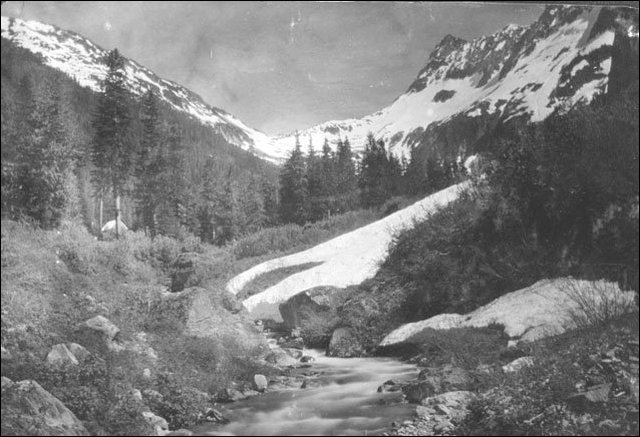
(Gilbert Landre cabin)
      This photo was taken decades ago, looking east towards Cascade pass. Gilbert Landre's cabin is in the left center near the creek and Johannesberg Mountain is out of the frame to the right. Photo courtesy of Dr. Albert Merritt and the Hazel Tracy collection. Hazel was a niece of Sadie Silverling, the legendary hotel owner in Marblemount. Hazel passed away in 2003.

Rowse, Rouse and Landre lead the first strikes
      The discovery of the Cascade district was made by George L. Rowse, John C. "Jack" Rouse and Gilbert Landre in September 1889 while tracing across the summit the great ledges exposed by the glaciers of Horseshoe basin and on the rim of Doubtful basin. They discovered the Boston ledge cleaving the summit and cropping far down the eastern slope and the Rowse-Rouse group located the Boston claim and Mr. Landre the Chicago on its west extension. In November of that year, Gilbert Landre and John Russner also located the Buffalo on the ledge.
      The Boston, owned by George Sheckler, George L. Rowse and [J.C.] Rouse has the greatest showing the district. The ledge crops on the west side of the Boston Glacier, which in places has worn away one of the walls, leaving a great body of galena exposed in a cliff to a height of forty feet. The ledge, which is divided in the middle by a three-foot horse of black porphyry, crops at his point to a width of fifty feet. A cross-cut of eighteen feet from the side of the glacier showed ore for ten feet, and a tunnel sixty feet along the wall showed galena and sulphides almost solid for the whole width. A 35-foot tunnel at a point 150 feet higher made a similar showing. The thickness of the ore body where it has been exposed some distance higher is four feet. Assays run as high as 110 ounces silver, 60 per cent lead and a little gold, and two tons shipped to the smelter returned $92 silver and lead per ton.
      Below the Boston the ledge forks, with galena predominating in one and sulphides in the other fork, and it is covered by the Chicago group of six claims held by Gilbert Landre and C.H. Landers. Several short tunnels have been run to strike the ore bodies in ledges which run about six feet wide, showing streaks of galena and sulphides.
      Southeast of the Boston and on the eastern rim of the glacier is the Ventura, or San Francisco, group of four claims, owned by the Cascade Consolidated Mining Company. They have, parallel with the Boston, a well-defined, three-foot ledge with six inches of galena showing in a small tunnel, samples from which assayed as high as 104.26 ounces of silver, 40.1 lead and $4.40 gold.
      West of the Boston, William McKay, John Millett and others have the Eldorado group of five claims on a parallel ledge four feet wide, well defined for some distance down the mountain, and carrying a pay streak, which runs well in gold. An 80-foot cross-cut will, when extended, tap the ledge to great depth, and a 40-foot drift shows good ore bodies, of which the main one assays $70 gold, silver and lead. On a parallel ledge, William Mertaugh, Charles Simpson, George W. Boles and Alexander Munroe have the Bunker Hill and Sullivan [claims], with three or four inches of high-grade ore, of which assays have run into the hundreds of ounces of silver.
      South of the Boston and traceable over the summit is a ledge on which Gilbert Landre and others have the Denver group of three claims. The ledge, which is nine feet wide and is broken by granite horses, carries eighteen inches of ore on one wall and two inches of mineralized talc on the other, shown in a 20-foot tunnel. Assays run as high as 140 ounces of silver and a trace of gold, and it is claimed that the ledge will average nearly $50. All of Messrs. Landre and Landers's interests, comprising 15 claims, have been acquired by the London and Galena Mining and Milling Company, which will develop them.

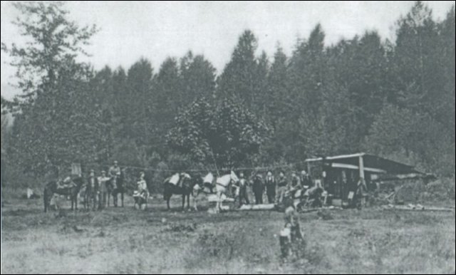
(Tommy Rowland's pack team)
      This is a photo of a pack team organized by Tommy Rowland at the turn of the century. Due to the primitive roads in the mining districts, the only way to ship supplies to miners and prospectors was by these pack teams. Rowland (also spelled Roland) came to the area in 1895 and built a cabin at Big Beaver creek. He was a highly eccentric man and sometimes called himself the Prophet Elisha. He was eventually judged insane and taken "outside" to be committed at the state hospital in Steilacoom. Photo from Dr. Jesse Kennedy and the North Cascades National Park Service Complex photo collection.

Silver Queen was the largest single investment
      The largest single investment in this district has been made by the Silver Queen Mining and Smelting Company, which has 14 patented claims in several groups. The Midas group is a mile west of Cascade Pass and has two claims on a ledge opened by tunnels 50 and 58 feet, with 12 to 16 inches of ore on the foot-well assaying $47 in silver and lead, and a two-inch streak which carried $604 silver, $12.50 lead, a total of $616.50.
      A cross-ledge is covered by three claims, on one of which a 20-foot tunnel shows one to four inches of ore assaying $98.90 and $101.80 from two samples. On another there are a 20-foot cross-cut and a 30-foot tunnel, with two to ten inches of fair ore showing on the floor all the way in, while the face of the drift is in ore of lower grade.
      The Soldier Boy ledge, the pioneer location of the district, in which a 12-foot tunnel shows ten to fourteen inches of good ore carrying some native copper and assaying $21. A cross-cut has been run seventy feet to tap this ledge in 250 feet at a depth of 400 feet. A ten-foot cut nine feet wide on another claim shows four feet of ledge matter with a two-inch pay streek on the hanging wall, and another cut 18 feet long and 12 feet deep shows five inches of iron sulphides and galena. The other claims are on a parallel ledge, in which a 16-foot cut shows four inches of iron pyrites and a little galena.
      The Johnsburg group consists of four claims on a ledge running up to the summit from the south bank of the Cascade river, three miles west of the pass, and cropping on the side of a gulch. A tunnel intended for a main working tunnel has been run 50 feet at a point 1,500 feet above the valley, but it is not yet through the slide rock. Another tunnel has been driven 200 feet at a point 500 feet higher and shows a good strong lege four feet wide, with eight inches of ore, while a third tunnel is in 50 feet at a point 800 feet higher and shows three feet of solid galena. Samples taken for the full width between the walls in each of these tunnels and ground together, gave an assay of $51.75 for all values.
      A number of ledges parallel with the Soldier Boy cut the curve of the basin, but have had a little work done on them. On one of these, R.A. Osterly and othes have the Grand Republic group of three claims, on which tunnels 25 and 15 feet and a 25-foot open cut shows a nine-inch pay streak carrying about $40 for all values. On other ledges with about as much pay ore are the St. Patrick and the Nip and Tuck [claims].
      The same mineral formation extends across to the middle and south forks of the Cascade, where the granite is cut by dikes of quartzite, gneiss and schist. The largest group, consisting of six claims, is the Fourth of July, owned by Joseph Rigby of Omaha. One ledge shows 24 inches of ore in a 14-foot shaft and 15-foot open cut, carrying galena, carbonates and suphurets to the value of $50 and upwards in gold and silver. Another ledge showing 12 inches of 480 ore in the croppings will be tapped by a cross-cut, now in forty feet. Another ledge shows 16 inches of pay ore in a 35-foot cross-cut; assays show 13 per cent copper, besides good gold and silver values. Below this, on the Granite [claim], Thomas Barrett of Woolley, has shown up 16 inches of pay ore in a four-foot ledge by means of a ten-foot shaft, and on the Jumbo, he has ten inches of pay ore, though a 40-foot tunnel on the ledge has not penetrated to the ore chute, showing in the croppings. Half a mile below this, he has the Homestake on a five-foot ledge, in which several small streaks aggregating 16 to 18 inches assay from $40 upwards.
      Charles L. Pollard has the Michigan group of five claims on two parallel ledges, which have been traced for 1,500 feet, One of these is five feet wide, with a 16-inch pay streak showing on the wall of a tunnel run 65 feet along the ledge. Two assays show 192 ounces of silver, 60 percent lead and $3 gold; 204 ounces silver, 40 percent lead, $3 gold. Southwest of this group, Thomas Barrett has the Black Canyon on a 4 1/2-foot ledge, in which an open cut 12 feet long shows 12 inches of good galena ore. A great blowout of oxidized iron, which has been traced 4,000 feet up the mountain from the south fork is covered by Richard Joy and Joseph Peraud with the Cascade group of three claims. A 65-foot tunnel shows a ten-inch streak of black sulphurets and iron pyrites carrying gold and silver.


See a list of many more mining stories and profiles


You can click the donation button to contribute to the upkeep of this site at a time when we may be forced to cut it back for lack of funds. You can also subscribe to our optional Subscribers-Paid Journal magazine online, which is about to enter its sixth year with exclusive stories, in-depth research and photos that are shared with our subscribers first. If you like what you read, t hank you in advance for whatever support you can provide.

Story posted on May 19, 2004, and last updated on Feb. 21, 2006
Did you enjoy this story? Please consider subscribing to the optional Subscribers Edition.
That is how we fund this grand project.
Please report any broken links or files that do not open and we will send you the correct link. Thank you.


Return to our home page anytime

You can read the history websites about our prime sponsors:
(bullet) Allelujah Business Systems/Copies/Mailbox, 133-B State St., Sedro-Woolley, 360 855-1157
Preserve your family keepsakes . . . allcopiersystems web page
(bullet) Schooner Tavern/Cocktails at 621 Metcalf Street in downtown Sedro-Woolley, across from Hammer Square: www.schoonerwoolley.com web page . . . History of bar and building
(bullet) Oliver Hammer Clothes Shop at 817 Metcalf Street in downtown Sedro-Woolley, 82 years.
(bullet) Joy's Sedro-Woolley Bakery-Cafe at 823 Metcalf Street in downtown Sedro-Woolley, 82 years.
(bullet) Check out Sedro-Woolley First for links to all stories and reasons to shop here first
or make this your destination on your visit or vacation.


(bullet) DelNagro Masonry Brick, block, stone — See our work at the new Hammer Heritage Square
See our website www.4bricklayers.com

(bullet) Would you like to buy a country church, pews, belfry, pastor's quarters and all? Email us for details.
(bullet) Are you looking to buy or sell a historic property, business or residence? We may be able to assist. Email us for details.
Looking for something special on our site? Enter name, town or subject, then press "Find"
Search this site powered by FreeFind
Did you find what you were looking for? If not, please email us and tell us what you seek and we will put it on our list to research. The more details, the better. Tip: Put quotation marks around a specific name or item of two words or more, and then experiment with different combinations of the words without quote marks.
Please sign our guestbook so our readers will know where you found out about us, or share something you know about the Skagit River or your memories or those of your family. Share your reactions or suggestions or comment on our Journal. Thank you for taking time out of your busy day to visit our site.
Sign Our Guestbook Get your own FREE Guestbook from htmlGEAR
View Our Guestbook
Remember, we welcome correction and criticism. Please click on the email slot at the right to report any problems with these pages or to suggest ideas for future stories. This is a completely free site. We fund it by providing an online magazine for paid subscribers. If you are not already a subscriber and you would like to help support our considerable research costs, you can subscribe for just $20.00 per year. As a paid subscriber, you will receive eight yearly issues plus many rare treats between times, including scans of photos and documents that illustrate local history, before they are shared with anyone else. You can go here for Subscription details and you can read the preview edition to see examples of our in-depth research. You may also order gift subscriptions for friends, family or clients who are interested in local history or students or military people who are away from home. Or you can email us for more details. Do you have scanned photos to share? Or you can mail us copies. See addresses to the right.
Email us at: journal@stumpranchonline.com
(Click to send email)
Mail copies/documents to Street address: Skagit River Journal, 810 Central Ave., Sedro-Woolley, WA, 98284.