Site founded Sept. 1, 2000. We passed one million page views on Memorial Day, May 2006
These home pages remain free of any charge. We need donations or subscriptions/gifts.
Please pass on this website link to your family, relatives, friends and clients.

(Seattle & Northern 1890)

Skagit River Journal

of History & Folklore
Subscribers Edition Stories & Photos
The most in-depth, comprehensive site about the Skagit

Covers from British Columbia to Puget Sound. Counties covered: Skagit, Whatcom, Island, San Juan, Snohomish & BC. An evolving history dedicated to committing random acts of historical kindness
Noel V. Bourasaw, editor (bullet) 810 Central Ave., Sedro-Woolley, Washington, 98284
Home of the Tarheel Stomp (bullet) Mortimer Cook slept here & named the town Bug

(Click to send email)

Canoe Trip to Skagit river, April 1876

By Eldridge Morse Jr., Publisher, The Northern Star, Saturday, April 29, 1876
Transcribed from microfilm at the Northwest Room, Everett Public Library
(Skagit River Journal editor's notes, clarifications and results of research in brackets: [ ])

      Business requiring my presence at Centreville in this country last week, I started on Monday morning, April 16, 1876, to Lowell to go across the trail to Mukilteo, intending to there catch the steamer Libby, go to Utsalady on her, and thence by row bat carrying the mails, would go to Centreville and transact my business in time to return by the same route. Reached Lowell early enough to have time to over the trail before the Libby would be at Mukilteo, were it not that Mr. E.D. Smith [pioneer of town of Lowell] had been getting out spars near the end of his logging road, blocking up the end of the trail, so much so that after some spent in searching, I concluded it would not be best to venture. Therefore, I returned to Lowell as the Fanny Lake came in sight, going down river. [Ed. note: the proper spelling for the town was Centerville in most records; we do not know why Morse used the anglicized version. Was it spelled both ways? We will need a Snohomish expert to answer that. Centerville was renamed Stanwood by Daniel Pearson in 1878.]
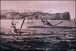
(Indian Canoes)
Settlement in those early days of the northern part of Washington territory was usually centered on the islands and around the mouths of streams and rivers. Both the hardy outdoorsmen and the tenderfoot quickly learned from the Indians that the best and least expensive mode of travel was by canoes crafted from cedar. This excellent illustration from the Outdoor Odysseys site is just one of the treats that the site offers people who want to learn those travel routes by water.

      Would have been in time for the Libby then, only the steamer had business that detained her until noon on the river. Seeing that she would be too late, I put my canoe aboard, reached Priest Point about noon [Priest Point is now part of Marysville, north and across the bay from Everett]. Started, as captain of my own craft, for the Stillaguamish; reaching Runnell's camp before dark where I stopped over night. I should have reached the Stillaguamish that night, only the sea was very rough, canoe [unreadable] the spray made quite wet, so I stopped a couple of hours on the beach after passing the heaviest seas, to warm and dry beside a large fire I built on the beach.
      Tuesday morning was very pleasant; reached Hatt's Slough early in the forenoon, visited Follansbee's and Long's logging camps, and T.S. Adams's place; returning to the Slough just after noon. [The slough was named for James Hatt, who settled on that waterway near the main channel of the Stillaguamish river in about 1870. In 2005, Hatt slough is now the main channel and the old main channel branches northwest. See our summation at the end of the article, which explains from the point of view of several experts the significance and location of what is now generally designated as Hatt slough and occasionally as Hat slough.] From there I went up the Slough to Perkins Portage. Two Indians took my canoe on their shoulders, carried it somewhat less than a quarter of a mile across the Portage to the Stillaguamish river. The Slough being a branch of the main river. I reached the river about four more five miles from its mouth, and about a mile below the Jam. I stopped at the residences of Messrs. Neville [maybe George Nevels?], [Captain Daniel] Marvin, Perkins, [Willard] Sly and Goodrich, and reached Centerville, near the mouth of river, just before dark, and transacting the business for which I came to the river on my way down.
      The next morning I concluded to go to the Skagit. There is quite a large Slough reaching from the Stillaguamish to the channel of the Skagit, running just outside of the dikes, but saving quite a long distance as the other route down the river, and adjoining Camano's island, is around an island formed by the Slough on one side and the main channel on the other.

LaConner and Swinomish
      I reached Skagit City without any accident in time to visit the Jam, where I found some 130 feet had been removed i the past three weeks, or some 350 feet in all, since they began work this spring; and returned to Skagit City the same evening. The next morning Messrs. Gage, Maddox, [James Cochrane] and myself started down the North fork of the Skagit in a row boat to La Conner. After seeing people there, finding the ranchers very busy putting in grain, etc., we went over to the telegraph station across the slough. Here I made the acquaintance of the telegraph operator, Mr. [James] H. Gilliland, and L.L. Andrews, the storekeeper at the [Swinomish] reservation. Mr. Gilliland was a former resident of this [Snohomish] county, leaving the river for this present business as telegraph operator in the employ of the Western Union Telegraph Co. some 12 years ago. During all this time he has been stationed at Tulalip, Hatt's Landing and at his present office.
      [Ed. note: James Cochrane had an impact on other parts of the county after his work on the Skagit river logjam, as one of the early settlers of Hamilton and later in LaConner. See this Journal site: . . . Wires to the telegraph station at Swinomish, with which Mr. Gilliland was affiliated were completed in early April 1865, just in time for local settlers to be informed of the assassination of Abraham Lincoln . . . See the story about Daniel and William Gage and Skagit City at this Journal site: . . . Lauren L. Andrews (also spelled Laurin) Lauren L. Andrews was the son of Peter Andrews and wife, settlers on the Black river in King county in the early 1860s. Mr. Andrews grew to manhood in Seattle and then set off on his own, becoming a merchant first and then a banker in LaConner . . . Please note: at that time Morse used the La Conner spelling, with the space. The Journal uses the LaConner version to be consistent for searching purposes. Both spellings were used by various sources and both are still used. See this Journal website for an 1889 profile of LaConner:]
      There are about one third as many Indians this [Swinomish] reservation, opposite LaConner, as at Tulalip. The average number of the Swinomish reservation being about 100 [with Supt. John McGlynn in charge]. We had previously met him, and were sorry not to find him at home. He left a shore time before our arrival, for the upper Skagit, to which point he had been ordered by Father Chirouse to investigate complaints made by settlers that the Indians near [the] mouth of [the] Baker river [now Concrete] were very troublesome to the settlers of Kullom, a settlement [of] some 50 above the [logjam]. [Ed. note: John P. McGlinn became the Indian agent at the reservation in 1872 and built a hotel on his namesake island downstream from LaConner. Father Eugene Casimir Chirouse was assigned to the mission in Yakima in 1847 and In 1857 he began working among the Snohomish Tribe and established the St. Anne Mission and boys school at the mouth of Ebey Slough near Tulalip and later a school and church on the Tulalip Reservation. He also worked with the Sisters of Providence to establish the Providence Hospital in Seattle and he had far-ranging responsibilities as a traveling priest throughout Washington territory. We have never heard of the settlement of Kullom; we hope a reader will have information.]
      We were very favorably impressed with Mr. Andrews. He is looked upon by all as a truly representative man for that region. The Indian trade is but a small part of his trade, as he divides with the Gaches Bros. [James and George] and Mr. [Bedford L.] Martin, the trade of LaConner and the Swinomish flats. We did not succeed in leaving LaConner before 9 p.m., Thursday evening. The tide was out, so we were a long time in getting over the flats and into the river.

Back to the forks of the Skagit river
      About midnight we reached the residence of Joseph Maddox, or Esq. Maddox as he is called. We awoke him, obtained a lantern and walked to the forks of the Skagit, stopping at D.E. Gage's store. Mr. Maddox is Justice for the Skagit River Precinct. He filled the position for a long time. Was one of the first settlers on the river. The Libby and the Utsalady steamer have each ascended the North fork to his place. Friday I spent on the South fork until late in the afternoon, when I started for the Stillaguamish, missed the North entrance to the slough, between the two rivers. Went up a blind about as far as my canoe would go on the island outside of the main slough, slipped up into the slough after leaving my canoe, found siwashes [frontier generic slang term for Indian, anglicized from the French sauvage and not capitalized as Indian is] who took me across the main slough, leaving me a short distance from Centerville. When I presented myself at the hotel there, I was plastered from head to foot with the nastiest, slimiest mud ever found in a tide marsh. [We assume that this Joseph Maddox was the eldest son of Rebecca Powers Maddox, whose husband, William Maddox, died during their covered-wagon journey west in 1853. She continued on with her children to Whidbey Island, where she filed on a 320-acre homestead in April. She remarried to Levi Ford in November 1855 and they eventually moved over to the south fork of the Skagit with the group of Whidbey settlers in 1870-71. We have a whole section on those settlers that you can read from this portal Journal site at: Wanda Stone of Cape Horn is a descendant of this family. Joseph would have been 38 in 1876.]
      Saturday afternoon, I started with Mr. Freeman and a siwash for my canoe. Although Mr. Freeman had diked in a portion of the island, he was certain there was no slough big enough for a canoe to go up, upon the course indicated by me, yet having been quite careful in the dark the night before to leave marks by which I could return to my canoe. We went on and found the canoe; the siwash took it around to Centerville, while we returned in a direct line, distance about one half mile. [Journal Ed. note: we wonder if Mr. Freeman was possibly Freeman Calvin Tingley, younger brother of Samuel S. Tingley, who settled near the north fork in 1867, near what later became known as Fish Town. Samuel became one of the best known figures on the river and eventually settled at Day Creek, while Freeman moved to British Columbia after the turn of the century.]
      Sunday I left Centerville, paddled to near Tulalip. An Indian then took my canoe to Priest Point, while I stopped a while at Tulalip, then walked over the trail to the Point. The next day went up river on the Zephyr. Was gone one week. Traveled not far from 140 miles, almost 20 miles by steamer, 20 afoot; the balance in canoe or row boat. A strong South wind was blowing most of the time on the Sound, so that much of the paddling was very tiresome; otherwise there were many advantages to be found in traveling this way, one being that I could go where I pleased, stop as long, and see whoever I pleased. We elsewhere give items collected on the trip.

Hatt slough
      Journal Ed. note: This slough was named for James Hatt, who settled on that waterway near the main channel of the Stillaguamish river in about 1870. There was also a Hatt's island and Hatt's landing, neither of which we have been able to locate on any map or find in any place name list. One source suggested that the island is near Tulalip, but that seems odd since Hatt settled on the banks of the Stillaguamish. Perhaps a reader can set us straight about those two places.
      Max Albert, a member of the Stillaguamish Flood Control District:

      [Morse's] tale of going up Hatt Slough to reach the Stillaguamish over Perkins portage (around the log jam that blew out circa 1910) sounds accurate, although at that point he would have been 8 rivermiles upstream of Stanwood, not 4 or 5. The river he reached is now called the Stillaguamish Old Channel (Old Stilly). Then it was the mainstem, now it's an 8-mile remnant channel, and Hatt Slough is the main channel of the river. We installed a flow-enhancement gate on the Old Stilly, just downstream of its divergence from Hatt Slough, in order to keep fresh water flowing down it during the summer. Otherwise, nearly all the base flow would discharge to the bay via Hatt Slough and the Old Channel stagnates. Hwy 532 (at Mark Clark Bridge to Camano) crosses the West Pass channel of the Old Stilly (the one that empties into Skagit Bay. Hatt Slough lies roughly two miles south.
      Hatt Slough (sometimes misspelled on maps as Hat Slough) was indeed named after James Hatt. For more info on him, you might check a history of Snohomish County homesteaders and farmers, which I once found at the Stanwood library. Sorry, but I can't recall the title. The Stanwood Historical Society also may have some information.
      The Slough is now the last reach of the Stillaguamish River mainstem, through which it empties into Port Susan Bay. The Stillaguamish Old Channel ("Old Stilly") which meanders north to Stanwood and empties into the bay via South Pass and West Pass channels, was once the mainstem, navigated by steamboats, but was gradually left behind as a remnant channel, after the river (in a series of floods) caused a massive avulsion that made Hatt Slough the main, shorter exit to the bay. This was partly due to the breaking of an enormous log jam in Hatt Slough (and people may have been pulling logs out of it for the lumber, weakening the jam). I'm told house and barn were also swept away in the event. Afterwards, the Corps of engineers twice attempted to maintain base flow down the Old Channel (to preserve navigation) by building "mattress sills" across Hatt Slough, but both in turn washed out after a few years and the Corps finally gave up the idea. That was circa 1915.

      Snohomish website:
      The gate is a main component of the $471,000 Stillaguamish Old Channel Habitat Restoration Project, co-sponsored by the Flood District and the Stillaguamish Tribe, aided by a $253,000 grant from the state Salmon Recovery Funding Board. Installed the summer of 2003 along with planting of thousands of trees and shrubs along the old channel. affordable way to prevent dry-season stagnation harmful to fish. The gate will force down the Channel an average of 750 thousand cubic feet (5.6 million gallons) of fresh water per tide.]
      Carroll Clark, long-time history researcher of Snohomish county, referred us to the 1906 book, Illustrated History of Skagit and Snohomish Counties, page 268:
      Hatt's slough cuts across from the Stillaguamish, six miles above its mouth, to Port Susan bay, a distance of three miles. On the south side of this slough is a marsh of six hundred acres, bounded on the west of Port Susan bay, south and east by highland, and north by the slough, except when timber lands above tidal overflow intervene. The tract south of Hatt's slough is sedimentary clay mixed with vegetable matter. There is no peat in it. The grass which grows wild here is like that north of the Nisqually and on the Samish flats; a hardy grass, which grows some eighteen inches high, seeds very thickly and looks like blue grass. Each summer about one hundred cattle and as many sheep get most of their living from this tract. The Stillaguamish delta comprises all lands between the main river and Hatt's slough, amounting to two thousand and ninety-five and three quarters by the United States land surveys.

Douglas slough and Phantom slough
      Journal Ed. note: The Douglas slough was one that Morse used when he headed home, south out of the mouth of the South fork of the Skagit — specifically the eastern waterway that is now called Tom Moore slough. The area along the shore below the mouth of the slough was all mudflats. About a mile south, he turned southeast into the mouth of Douglas slough that ran in pretty much of a straight line to the old main Stillaguamish river channel, about .2 miles west of Stanwood. We found that slough on the 1897 Army Corps of Engineers map that was drawn after the monster flood of that year.
      The final mystery that is as of yet unsolved is the Phantom slough of no name that Morse describes as connecting the South fork of the Skagit with the Stillaguamish and being just barely navigable by canoe. We found such a slough unnamed on a 1909 map but we have no more information about it yet.


Links, background reading and sources


      See this Journal website for a timeline of local, state, national and international events for years of the pioneer period.
      Search the entire Journal site.

You can click the donation button to contribute to the upkeep of this site at a time when we may be forced to cut it back for lack of funds. You can also subscribe to our optional Subscribers-Paid Journal magazine online, which is about to enter its sixth year with exclusive stories, in-depth research and photos that are shared with our subscribers first. If you like what you read, thank you in advance for whatever support you can provide. You can go here to read the preview edition to see examples of our in-depth research.

(bullet) Story posted on March 5, 2005
(bullet) Did you enjoy this story? Remember, as with all our features, this story is a draft and will evolve as we discover more information and photos. This process continues until we eventually compile a book about Northwest history.
(bullet) Can you help? We welcome correction and criticism.
(bullet) Please report any broken links or files that do not open and we will send you the correct link. With more than 500 features, we depend on your report. Thank you.


Return to our home page anytime

You can read the history websites about our prime sponsors:
(bullet) Jones and Solveig Atterberry, NorthWest Properties Aiken & Associates: . . . See our website
Please let us show you residential and commercial property in Sedro-Woolley and Skagit County 2204 Riverside Drive, Mount Vernon, Washington . . . 360 708-8935 . . . 360 708-1729
(bullet) Schooner Tavern/Cocktails at 621 Metcalf Street in downtown Sedro-Woolley, across from Hammer Square: www.schoonerwoolley.com web page . . . History of bar and building
(bullet) Oliver Hammer Clothes Shop at 817 Metcalf Street in downtown Sedro-Woolley, 82 years.
(bullet) Joy's Sedro-Woolley Bakery-Cafe at 823 Metcalf Street in downtown Sedro-Woolley, 82 years.
(bullet) Check out Sedro-Woolley First section for links to all stories and reasons to shop here first
or make this your destination on your visit or vacation.
(bullet) DelNagro Masonry Brick, block, stone — See our work at the new Hammer Heritage Square
See our website www.4bricklayers.com
(bullet) Are you looking to buy or sell a historic property, business or residence? We may be able to assist. Email us for details.
(bullet) Peace and quiet at the Alpine RV Park, just north of Marblemount on Hwy 20
Park your RV or pitch a tent by the Skagit river, just a short drive from Winthrop or Sedro-Woolley

Looking for something special on our site? Enter name, town or subject, then press "Find" Search this site powered by FreeFind
    Did you find what you were seeking? We have helped many people find individual names or places, so email if you have any difficulty.
    Tip: Put quotation marks around a specific name or item of two words or more, and then experiment with different combinations of the words without quote marks. We are currently researching some of the names most recently searched for — check the list here. Maybe you have searched for one of them?
Please sign our guestbook so our readers will know where you found out about us, or share something you know about the Skagit River or your memories or those of your family. Share your reactions or suggestions or comment on our Journal. Thank you for taking time out of your busy day to visit our site.

View My Guestbook
Sign My Guestbook
Email us at: journal@stumpranchonline.com
(Click to send email)
Mail copies/documents to Street address: Skagit River Journal, 810 Central Ave., Sedro-Woolley, WA, 98284.