Celebrating 3+ years on the web and passing 150,000 page views in April 2004
This is a page from our Subscribers Edition. Our free site remains free. How to subscribe to our separate online magazine or donate to our project
|
of History & Folklore
Subscribers Edition Stories & Photos
|
|
Covers from British Columbia to Puget sound. Counties covered:
Skagit, Whatcom, Island, San Juan. An evolving history dedicated
to the principle of committing random acts of historical kindness
Noel V. Bourasaw, editor  810 Central Ave., Sedro-Woolley, Washington, 98284 810 Central Ave., Sedro-Woolley, Washington, 98284
Home of the Tarheel Stomp Mortimer Cook slept here & named the town Bug
|

|
Introduction to Forestry Districts of the
North Cascades in Washington state
|
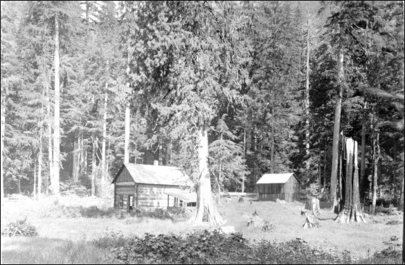
Backus Ranger Station started with a cabin in the clearing just west of Marblemount
|
This feature will serve as a launching point for a whole series of stories about the institutions and the people who have administered the forests and mountains of the North Cascades range of Washington state and also in British Columbia. Each story will lead you to more research sources. The National Park Service websites to which we refer are very rich with footnotes and cross-links to other history, along with photos. We are especially indebted to Gretchen Luxembourg, who wrote the wonderful cultural overview of the Cascades in 1999. We hope that readers who have either resource materials and links or family memories, documents and photos will email us and share information that will update the present stories or lead to new stories over the upcoming years.
- Backus Ranger Station at Marblemount, the portal to the Mount Baker and Cascades mountain districts. Along with information about the Bacon creek and Texas Pond substations and the work of the CCC in building many camps in the Cascades from 1933-38.
- Tommy Thompson, everyman and longest serving forest ranger from 1907-43 and his wife, Ella, sometimes called the Boss at Backus.
- The hair-raising story of how tiny Ella Thompson rode the go-devil tram across the Sauk river and almost got stranded in the middle over the rushing water.
- Henry Thompson, Tommy's father, the famous carpenter and bridge-builder who brought his family to the U.S. from England in 1885. He and his son Richard were county commissioners and are immortalized in Concrete's Thompson bridge.
- Part one of our exclusive section about Poets on the Peaks by John Suiter, the book about Beat writers Gary Snyder, Philip Whelan and Jack Kerouac and their years as firewatchers in the North Cascades from 1952-56.
- Also see our original story of The Firewatchers of the North Cascades, which is timely reading as the high country warms up. This story is from our old website and some links may not work.
- Comprehensive three-part story of Sauk City, gateway to Monte Cristo, and Sauk on the Skagit north shore. More photos from Sauk descendant Diane McMurdie and updated chapter 3 of the Sauk story: what happened to the early pioneers. We are in the process of updating this story after hearing from descendants of the Stafford family. Can you help?
- Please return here to get the links to read stories in this section.
Backus Ranger Station, Marblemount
From website: www.nps.gov/noca/hrs6-2b1.htm www.nps.gov/noca/hrs6-2b1.htm, www.nps.gov/noca/hrs6-2b1.htm www.nps.gov/noca/hrs6-2b1.htm transcribed by Larry Spurling
Ranger stations for the Skagit and Stehekin Districts were located in Marblemount and Stehekin respectively. The site for the Skagit station, known as Backus Ranger Station, was carefully selected from limited good land. After acquiring early settler Frank Backus's homestead, the United States Forestry Service [USFS] slowly obtained other tracts of land in the northwest part of section 12 (Township 35 North, Range 10 East). By 1907, a sizable amount of land was officially owned by the United States Forestry Service [USFS] and used as an administrative site. Ranger Axel Larson built the first structure on Backus two years later. In the spring of 1909, he completed a small, one story, wood frame, hip-roofed house of four rooms for A.R. Conrad, the district's first assigned ranger.
Set deep in the woods against a mountain backdrop, the Backus Ranger Station evolved over the years into a substantial complex. By 1915 a barn, chicken house, and woodshed were built on the grounds. Before the close of the same year, a foundation for a new barn was in place. A USFS supervisor's inspection report of 1921 discussed the permanent improvements at the Backus Ranger Station.
The land is well cultivated and since [Tommy] Thompson was raised on a farm the proper rotation of crops is planned to get the best results. The fences are well kept, and all small outhouses kept repaired. The location of the station for accessibility, surroundings, water supply, pasturage, etc. is the best that could be secured??The entire tract has been cleared. Most of the stumps have been removed??All complete buildings are kept neat and clean. The grounds surrounding are always in good shape??.The barn is big, well arranged and always kept clean and repaired. One room is partitioned off for the express purpose of storing fire tools and supplies.
By 1926 the first residence was replaced by a gable-roofed wood frame house of similar proportions, and an identical structure to serve as an office was built (ca. 1929) adjacent to the residence. In the 1930s, the USFS embarked upon an ambitious building program at the Backus site. With CCC assistance [1933-1938], the USFS was able to increase the capacity and physical plant of the ranger station twofold. A warehouse, shop, garage, and possibly an additional residence were all added to the grounds by the CCC. Carefully sited and constructed of similar materials and design, the new structure gave Backus the cohesiveness and definition of a complex. The station appears different today; while a few buildings remain intact, others have been removed or altered, and a new infill structures lack the architectural distinction of their predecessors.
Another look at Backus Station
[Ed. note: This section is from The Mt. Baker Almanac, Book of Historical Facts and Figures, by H. Phil Brandner, forest supervisor, and Newton Field, 1950. It is a historical record of the Forestry Service that we bought at a garage sale years ago. We will excerpt from this document in several features of this section.]
Improvements at the old Fred Backus homestead began in 1909. Forestry Service supervisors included C.H. Park and his deputy, H.F. Brundage. The Field Force for the area included: Baker river — Oliver S. Coleman, assistant forest ranger; Backus — Axel E. Larson and Alred B. Conrad, both assistant forest rangers; Finney creek — C.C. McGuire, forest guard, and Ralph A. Hilligoss, assistant forest ranger; and Henry Soll, forest guard; Glacier — J.R. Smith, assistant forest ranger.
Improvements that year included a four-room ranger's residence at the Backus Ranger Station was completed by ranger Axel Larson. When completed, the station was occupied by Alfred B. Conrad. The Texas Pond Ranger Station was surveyed and posted by Ranger A.B. Conrad. The Baker river trail, up Baker river and Swift creek, was completed that year, providing a trail around Mt. Baker. The trail connects with the Nooksack river trail from Glacier and crosses over Austin pass. The improvements at the Finney Creek Ranger Station were purchased for $300 from O.M. Bristol, who squatted on the site in 1904.
Bacon Creek Guard Station
Beyond the district station at Backus, the first guard station encountered along the Skagit River was at Bacon Creek. By 1913 a ranger station here was delineated on USFS maps. Although documentation suggests it was still in operation by 1926, by 1931 the station no longer appeared on forest maps. Upstream from Bacon Creek, the USFS established a ranger station near the bank of Goodell Creek. Undoubtedly this station was also short-lived, as it appeared on a 1913 WNG map but not on subsequent forest maps. In 1937 USFS focus shifted upstream to Newhalem. The USFS had tentative plans ". . . to provide for the eventual construction of a new ranger station site along the east bank on the lower end of Goodell Creek . . . " This new headquarters station at Newhalem was to replace the Backus Ranger Station. In 1938 the forest supervisor recommended the construction of an office at Newhalem that could provide, at minimum, offices of considerable size, an exhibit space, and two rooms for use as bachelor quarters. Because by this time Seattle City Light owned all of the land in this narrow section of the valley, they selected a "suitable" lot for use by the USFS. These plans never materialized, however, and Backus remained the district's headquarters.
[Ed. note: Bacon creek was named for Albert Bacon who homesteaded there by early 1884. He married an Indian woman named Elizabeth "Lizzie" Harry and she gave birth to Leonard Bacon on Nov. 7, 1884, at their cabin. Leonard died in 1955, one of the most colorful and beloved of the early upriver pioneers. Albert died in 1897 when a canoe on the Skagit river overturned and spilled their occupants into the rushing water. He was trying to save them.]
North Cascades National Park Service Complex
For many of our stories about the North Cascades and the upper river, we are indebted to the National Park Service and especially the work of Dr. Jesse Kennedy, the branch chief of the Marblemount Curation Facility. He and Brooke Keleman, museum Technician, and Bob mierendorf, Park Archeologist, have helped us locate sites and research history. Jesse explains their facility next to the old Backus Ranger Station as follows:
Historic Preservation — The cultural resources branch is responsible for the inventory and monitoring of over 81 unique and nationally recognized buildings and structures within North Cascades National Park Service Complex [NOCA]. Additionally, there are remnants of at least 23 historic cultural landscapes within park boundaries. These historic treasures range from abandoned mines to a historic hotel that captures the spirit of rustic recreation in wilderness areas. These structures are regularly inventoried and their condition is monitored to ensure that they are managed in the most efficient and cost effective manner.
Museum and Archives — The Marblemount Curation Facility is a multi-park repository for the museum collections from Ebey's Landing National Historical Reserve, North Cascades National Park Service Complex and San Juan Island National Historical Park. The combined collections total over 2.0 million objects and are rapidly growing in direct proportion with inventory, monitoring, and research activities of these NPS units. We also accept public and private donations that fit within our defined Scope of Collection statement. The museum collections are divided into three main areas, cultural resources, natural history, and the archival collections. The cultural museum collections include both prehistoric and historic objects. The prehistoric objects provide valuable information about Native American life in the North Cascades. The historic artifacts document early exploration and settlement of the area, fishing, trapping, logging, and mining in the mountains. The natural collections include biological, geological, and paleontological specimens. The extensive archival collection includes archeological project documents, historical records, park administrative documents, resource management records, maps, drawings, documents associated with natural resource studies and inventories, photographs, reports, oral histories, and electronic media. The museum collections serve as scientific and historical documentation for the parks' resources. They provide baseline information for park planning, management activities, research, and interpretive and educational programs. National Park Service museum collections preserve and protect the nation??s natural and cultural heritage for future generations.
Civilian Conservation Corps (CCC) — Works Progress Administration (WPA)
(From Nation Park Service website: http://www.nps.gov/noca/hrs1-1.htm)
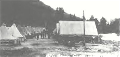 |
The Civilian Conservation Corps [CCC] camp at Bacon Creek. Courtesy of the Thompson Collection, Washtucna, Washington: Photo by Lloyd Seabury, 28 January 1933. Lloyd Seabury was also a forest ranger with Tommy Thompson and he moved here with his parents and their family in 1900 from Plainview, Nebraska, homesteading next to the Wicker family in Skiyou. His brother Howard was the Sedro-Woolley city attorney, starting in 1902.
|
The Civilian Conservation Corps (CCC) was another government entity which made a noticeable impact in the North Cascades. Born from the despair of a debilitating nationwide depression, the CCC was one of many programs established following the passage of the Emergency Conservation Work Act of 1933. President Roosevelt envisioned a peacetime army of unemployed young men working in forests and parks throughout the United States, learning new skills and completing much-needed conservation work — a "man building as well as forest building" opportunity. Within a few months of the bill's passage, 1300 CCC camps were in place across the country.
Between the years 1933 and 1942 thousands of young men were recruited, tested, and assigned to CCC camps prepared for work. Transportation to the camp site, camp construction, and management were undertaken by the United States Army, while the Departments of Agriculture and Interior selected the camp sites and planned, designed, and supervised all work done by the CCC. The cooperation between these various agencies was a remarkable success, and so was the CCC itself. Not only were men relieved of unemployment, but they were offered new challenges. They enjoyed new experiences such as being away from home, learning to live cooperatively with others, and working in a healthy environment -- and they also learned skills. The enrollees were supplied with housing, food, clothing, and a stipend. They were expected to send $25 of their $30 a month salary home to their needy families. The states benefited as did the young men. In Washington State alone, a total of 50 camps employed 73,339 individuals whose work accomplishments included the construction of lookout structures, telephone lines, truck trails and minor roads, tree planting, fighting forest fires, and reducing fire hazards.
In the environs of the North Cascades, CCC camps were established at Glacier, Bacon Creek, Darrington, Chelan, and 25-Mile Creek on the west shore of Lake Chelan. In the area of today's park, the Skagit camp (#F-13) at Bacon Creek worked on projects in the Skagit Ranger District of the Mount Baker National Forest. Several years later in Stehekin a CCC side camp was established from the main camp at 25-Mile Creek (#F-77). These side or "spike" camps were approved only when travel time to and from the main camp and the work site was excessive.] Though short-lived, the Stehekin side camp was a great benefit to the Chelan National Forest.
At the main Skagit camp (established in 1933 with a crew from Illinois), the CCC enlarged the small Backus Ranger Station by constructing a warehouse, a blacksmith shop, garage, oil station, and residences. They cleared land, landscaped the grounds, and painted the structures, all under the supervision of the USFS. Other work in the district included the clearing and grading of the existing Skagit road and Bacon Creek road. A bridge spanning Bacon Creek was built by a 35-man CCC crew in 1933. The CCC built a lookout on Bacon Peak in 1935 and also improved the old puncheon road along the Skagit River, originally built by settlers in the early twentieth century. Unofficial side camps with a total of 18 men were established in 1933 at Reflector Bar, on the Cascade River, and at Crater Mountain, primarily for trail and building maintenance, fence and telephone line construction, and campground development. The main camp was vacated by the winter of 1937, but re-established and active through the summer of that year. In the spring of 1940 the bunkhouses were removed, although a CCC crew did return the following year to complete additional work.
Operating somewhat later than its counterpart in the Skagit district, the CCC side camp in Stehekin was activated in the late 1930s, drawing 16-20 men from the 25-Mile Creek camp situated downlake. A 1939 inspection report of the camp noted: "This camp is considerably below the minimum standard for side camps and cannot be brought up to standard in its present location by reason of the topography and limited space." Living quarters were indeed spare: four 16 feet x 16 feet pyramid tents, "all in poor condition," and two 12' x 18' "out-dated portable bunk houses." Despite the uncomfortable living conditions, the Stehekin CCC crew accomplished a great deal. Three sturdy log shelters standing today were constructed for recreational purposes at Bridge Creek, High Bridge, and Flick Creek. In 1937, a CCC crew built a new hay barn and horse corral at the USFS Purple Point Ranger Station. The following year, a two-man CCC crew constructed a lookout on Goode Ridge. Trails, telephone lines, and bridges in the backcountry were also improved, upgraded, and rebuilt by these hard working young men.
To supplement the CCC, the Emergency Relief Appropriation Act established the Works Progress Administration (WPA) in 1935. This program continued to provide relief to the distressed nation by employing workers on public projects between 1935 and 1943. In the North Cascades, Whatcom County established a WPA construction camp on Ruby Creek for the purpose of building a road. The Ruby Creek road was to be a mine-to-market road connecting Hart's Pass road with Slate Creek road. Portable buildings including a barn, cookhouse, and a bunkhouse, were brought from the abandoned Bacon Creek CCC camp. That summer four miles of road were completed and then, possibly because of a lack of government funds, all work ceased on the project. The buildings passed to USFS ownership, eventually fell into disrepair, and were removed. The rising waters of Ross Lake flooded a section of the four-mile road but more than two miles remain intact along the north side of Ruby Creek. Of the former camp itself, only the Ruby barn remains to mark the site.
[Ed. note: Sally Sloan Munck, a descendant of Lyman pioneer families, notes that there was a significant CCC camp just a few hundred yards east of downtown Lyman. The late Bud Meyera and Howard Miller also described the camp to us. "Last time I saw it the infirmary, dinning hall, garage and several of the cabins were still there," Sally recalls, "The infirmary had been converted into a home and it had the most beautiful stone fireplace. That era raises lots of questions: did the government pay for the property or just rent it?" We hope that a reader will have family memories, documents or photos so that we can follow up on that camp.
Frank Wilkeson observes the formation of the forest reserve
Longtime readers of the site have probably read our featured New York Times columns written by Col. Frank Wilkeson in the 1890s while living in Skagit county. We have been researching his life for nearly eleven years and in 2000 we were fortunate enough to cross paths with Patricia McAndrew, who will publish a book on Frank later in 2004. About a year ago, Patricia sent us a note about Frank that is very pertinent to this introductory story:
There was one western correspondent in the early 1880s who writes a lot but doesn't have the flow to his prose that Frank does. However, a search of some news items from 1897 turned up the following juicy tidbit and here are some notes from it. I can only imagine how blue the air must have been in Washington state when news of [President Grover Cleveland's] action came over the wires. The item is datelined Tacoma, March 7, 1897. It says that three Forestry Reservations have been set aside by Grover Cleveland. The headline is: MR. CLEVELAND'S MISTAKE. I am sure Frank wrote this news story.
It seems that business interests in the state were greatly alarmed by Pres. Cleveland's action on Feb. 22 of that year. The largest reservation was 66 x 100 miles long, and took up half of Whatcom, Skagit, Snohomish and Okanagan counties, including Hamilton and several other towns. This has affected up to 10,000 settlers and mineral claims locators who can't file regular claims because the lands are in mountainous districts which remain unsurveyed [surveying upriver did not begin until about 1883].
"These honest occupants have been building homes in the wilderness, clearing land, and endeavoring to develop latent mineral wealth, waiting patiently until surveys should be extended enabling them to make entries and obtain title. Now, at one pen-stroke, their rights are swept away and they become trespassers."
Settlers affected are greatly alarmed. Tacoma and other Chambers of Commerce have called special meetings and Congress will be urged to repeal the executive order at the next session. "The largest reservation embraces coal lands and thousands of gold and silver claims in Silverton,. Stillaguamish, Monte Cristo, and other mining districts. No further locations can be made and thousands of prospectors have been preparing to invade these districts this Spring." They are sure Mr. Cleveland was not aware of all this at the time he signed the order.
|
Click on these thumbnails for full-sized photos
|
|
|
|
|
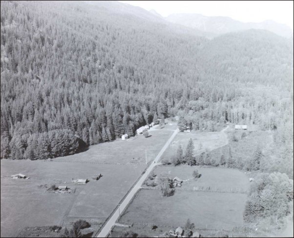
Far left: Aerial view of Backus Ranger Station about 1942, looking north, up the road that still leads north from Hwy 20. Center: By the 1930s, families lived at the site and there was a village atmosphere just two miles northwest of the other village, Marblemount. Right: The woodshed, one of the most important early buildings, photographed in October 1942. Photos by Rudo L. Fromme, who transferred from the Rainier Forest to Backus in 1934 and served through 1943 when he retired as did Tommy Thompson. Fromme had 37 years service, just one less than Thompson.
|
We strongly suggest that you read this comprehensive National Parks Service section on the history of the North Cascades and the forestry districts, which was largely written by Gretchen Luxembourg. It has dozens of stories about the forests themselves and the people who made them their homes. In this section and others, you will often run into an alphabet soup of government agencies. We spell them out for you here: CCC — Civilian Conservation Corp; FARC — Federal Archives and Records Center, Sand Point, WA; GLO — General Law Office; NOCA — North Cascades National Park Service Complex (Administrative Offices in Sedro Woolley; Skagit and Stehekin Districts); NPS — National Park Service; RG 95 — Record Group 95: USFS records; SCL — Seattle City Light; USFS — United States Forest Service; USGS — United States Geological Survey; T — Township; R — Range; N,S,E, or W — Compass directions; Sec. — Section. These and an overview are included in the Historic Resources Study section.
Story posted on April 15, 2004
Please report any broken links or files that do not open and we will send you the correct link. Thank you.
|
You can read about our prime sponsors:
Read the history websites of our two newest sponsors and supporters:
Oliver Hammer Clothes Shop at 817 Metcalf street in downtown Sedro-Woolley, 82 years
Bus Jungquist Furniture at 829 Metcalf street in downtown Sedro-Woolley, 36 years
Peace and quiet at the Alpine RV Park, just north of Marblemount on Hwy 20
Park your RV or pitch a tent by the Skagit river, just a short driver from Winthrop or Sedro-Woolley
College Way Antique Mall, 1601 E. College Way, Mount Vernon, WA 98273, (360) 848-0807
Where you will find wonderful examples of Skagit county's past, seven days a week
North Cascade Ford, formerly Vern Sims Ford Ranch,
West Ferry street and Crossroads/Highway 20
either on the Sedro-Woolley page or directly at www.northcascadeford.com
DelNagro Masonry Brick, block, stone — See our work at the new Hammer Heritage Square
See our website www.4bricklayers.com
33 years experience — 15 years as a bonded, licensed contractor in the valley
Free estimates, reference, member of Sedro-Woolley Chamber (360) 856-0101
|
|
|
Did you find what you were looking for? If not, please email us and tell us what you seek and we will put it on our list to research. The more details, the better.
|
Please sign our guestbook so our readers will know where you found out about us, or share something you know about the Skagit River or your memories or those of your family. Share your reactions or suggestions or comment on our Journal. Thank you for taking time out of your busy day to visit our site.
|
Sign Our Guestbook

View Our Guestbook
|
Remember, we welcome correction and criticism. Please click on the email slot at the right to report any problems with these pages or to suggest ideas for future stories. This is a completely free site. We fund it by providing an online magazine for paid subscribers. If you are not already a subscriber and you would like to help support our considerable research costs, you can subscribe for just $17.50 per year. As a paid subscriber, you will receive six yearly issues plus many rare treats between times, including scans of photos and documents that illustrate local history, before they are shared with anyone else. You can go here for Subscription details and you can read the preview edition to see examples of our in-depth research. You may also order gift subscriptions for friends, family or clients who are interested in local history or students or military people who are away from home. Or you can email us for more details. Do you have scanned photos to share? Or you can mail us copies. See addresses to right.
|
Email us at: journal@stumpranchonline.com

Use this email for scans and large files
Mail copies/documents to street address: Skagit River Journal, 810 Central Ave., Sedro-Woolley, WA, 98284.
|
Skagit River Journal free resources home page
If you are not a subscriber, go to story list of the Skagit River Journal subscriber edition,
including all archives.
Skagit River Journal online subscriber edition Preview edition page