Site founded September 1, 2000, passing a half million page views in July 2005
These home pages remain free of any charge. We need donations or subscriptions/gifts for students, military and family. Please pass on this website link to your family, relatives, friends and clients.
|
|
of History & Folklore
Subscribers Edition Stories & Photos
The most in-depth, comprehensive site about the Skagit.
Covers from British Columbia to Puget sound. Counties covered: Skagit, Whatcom, Island, San Juan. An evolving history dedicated to the principle of committing random acts of historical kindness
|
Noel V. Bourasaw, editor  810 Central Ave., Sedro-Woolley, Washington, 98284 810 Central Ave., Sedro-Woolley, Washington, 98284
Home of the Tarheel Stomp Mortimer Cook slept here & named the town Bug
|

|
Paul Dorpat's photo book series, part one:
Chuckanut Drive, Interurban, Great Northern
Part 1 of 6-part series
Paul Dorpat, author of the very popular Seattle Now & Then series of books along with articles in the Seattle Times, is working on a new book that will include historic photographs taken all over Washington state. For years now, he has been fascinating us with an historic photo placed side by side with another that shows the present site. The new book will be titled Washington State Then and Now, and the photographer of the "Now" photos will be Jean Sherrard. As we discussed his newest project, he asked me if I knew of photographs he should consider including, and then he shared with me some photos that almost made the cut.
|
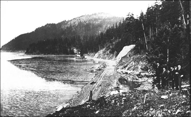
This photo supplied by Paul Dorpat apparently shows construction of the railroad bed for the Great Northern below Chuckanut Mountain. We are looking north. This is part of what became known as the Chuckanut cutoff, which replaced the old route that GN had taken over from the Fairhaven & Southern line, east of the mountain and along Friday creek. We know that the Great Northern used this new route to Chuckanut in 1902-03 and tore up the old line, so this photo must have been taken soon after the turn of the 20th century. Paul believes it was taken from some spot up the slope from Pigeon Point. We have no idea who the gentleman are who you can see posing at the right.
|
After discussion, I thought it would be a good idea to ask our readers to look at the photos and see if they can help with the provenance, i.e. the photographer, when it was taken and exactly where, the subject; names of people, towns and/or buildings; and any other details they might recognize. In addition, we hope that readers will submit sample scans of photos in their collections. Paul looks at both traditional photographs and postcards, as well as promotional brochures and maps with photos. If you have one or more you would like considered, please email us and attach the photo, preferably in .jpg format. We prefer low resolution to begin with and please keep the file size to less than 500 megabytes, 200 or less, if you can edit the photo in your own program. If you have a huge file that you cannot reduce in byte-size, please email it to our alternate address . . . otherwise, please use our main email address by clicking our email button above or at the bottom of this article. That is also the email you should use for sending us details or your memories about each photo.
We start with the ten photos below, all of them involving Chuckanut drive or the Interurban or Great Northern track lines that ran alongside. We are working on three different stories that will explore each of these key transportation routes and we have included some other photos from our files. Your help with the photos will make the story even more informative and interesting. Thank you in advance for any help you can provide.
|
Click on these thumbnails for full-sized photos
|
|
|
|
|
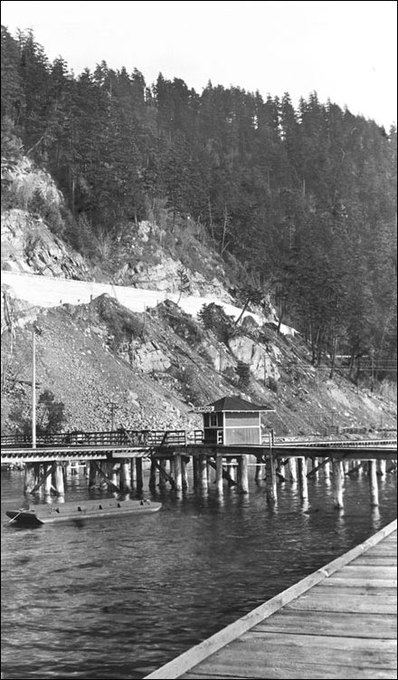
Far left: This photo supplied by Paul Dorpat was taken from the water looking east towards Chuckanut Mountain, with the trestle of the Pacific Northwest Traction Co. Interurban in the foreground. You can see the sign on the north end of the small depot reads "Seawood." We checked the schedule of the Interurban and determined that Seqwood was located just over one mile north of the Samish stop and 2.5 miles north of Blanchard, and 2 miles south of Clayton Bay. Photos in the book, The Electric Railway Era, by Daniel E. Turbeville III show that this trestle was part of a four-mile "scenic" route that hugged the shore on Samish Bay from Blanchard to Clayton Bay. Old-timers recalled that ten years later, this part of the route was a white-knuckle ride but the rewards of the views of the sound made it all worth it.
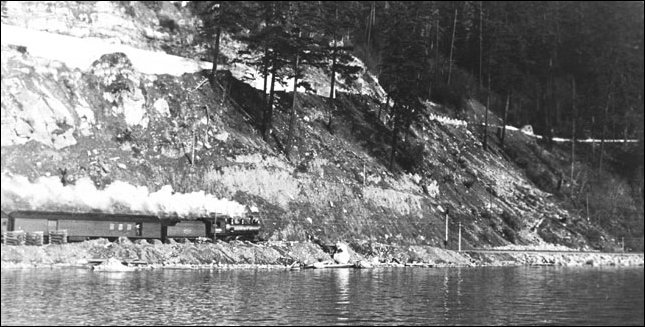
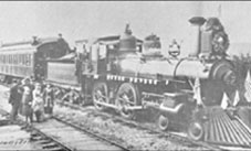
Center: This photo supplied by Paul Dorpat makes us especially curious. We know that this is the southbound Great Northern train in the foreground, belching steam while hitting a pretty good clip on a straightaway that is the same route as the present Vancouver-Seattle train. That is the new Chuckanut drive up above on the horizontal cut with a steep rise at the upper left. Until we have an expert opinion, we will assume that the photographer was standing on the trestle of the Pacific Northwest Traction Interurban, looking east, probably somewhere between Seawood and Samish.
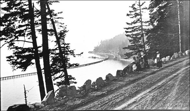
Right: This photo supplied by Paul Dorpat was taken from side of Chuckanut Mountain, looking northwest at Samish Bay and the Pacific Northwest Traction Interurban trestle. From the bow of the trestle, we suspect that the photographer was standing someplace between the Samish depot stop and Pigeon Point to the north. That may be the Seawood depot stop on the trestle. The mud and dirt road is the young Chuckanut drive, so this photo was probably taken sometime after 1915. The small boulders along the route that are a signature of Chuckanut drive.
|
Great Northern Railway
The Great Northern came first, but part of its route through Skagit and Whatcom counties came from the purchase of the Fairhaven & Southern Railroad that connected the old town of Sedro on the Skagit river — and the nearby Cokedale coal mines, with the town of Fairhaven. That relatively new town was about two miles south of old Whatcom on Bellingham bay. Nelson Bennett, a construction contractor who helped build the Northern Pacific Railroad across the Plains and the Rockies, built the line from 1888-89, and the first train ran on a 26-mile diagonal route on Dec. 24, 1889. The original route skirted Chuckanut mountain to the east and ran along Friday creek and lake Samish.
James J. Hill, the owner of the Great Northern, bought the F&S line in early 1890 as a hedge while he was still building his line west across the state from Spokane Falls. The Seattle & Montana Railroad, another line that Hill would eventually own, built a route north from Seattle in 1890-91, which passed through Mount Vernon that fall. It met the F&S route near the town of Belfast, north of Burlington. After Hill gained control of all the lines plus the Northern Pacific, he decided to abandon the old Friday creek route and build what was known as the Chuckanut cutoff that angled north-northwest through Olympia Marsh to the site of the Blanchard sawmill and then hugged the cliff along the west side of Chuckanut mountain, eventually entering Whatcom county and Fairhaven.
|
Mystery 1: This is the first of our mystery photos that were sent to us on a disk many years ago without any explanation of who took them or of their provenance. We hope that a reader can help identify them. This one is a beautiful panorama of lower Chuckanut drive. We think that it is taken from the old Blanchard Mill site, looking west. We think that spit of land that curls in the background is the tip of Samish island.
|
Pacific Northwest Traction Co. Interurban
The Stone and Webster company began as a partnership in Boston in 1889 as one of the country's first electrical engineering consulting firms. Even during the nationwide Depression of the 1890s the company became very successful building hydroelectric installations in new England and then branched out into other electric industries including electric railways in New England, Texas and then in the Puget sound region. In 1900 they merged and managed eight small street railways in Seattle under the name of the Seattle Electric Co. They soon added street railway systems in Tacoma and Everett and in 1902 they bought the Fairhaven and New Whatcom railway, just before the city of Bellingham consolidated in 1903.
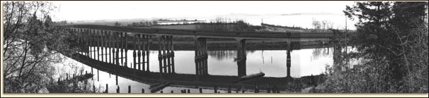
They administered the Whatcom properties under the name of Whatcom County Railway and Light Co. and after a couple of lean years, they began planning an interurban rail line from Bellingham to Seattle. The Bellingham and Skagit Interurban Railway was born on May 18, 1910, and the company planned tracks to Mount Vernon, Sedro-Woolley and Anacortes and other points. The prefabricated bridge — Hibridge, over a ravine next to Chuckanut Bay was completed in May 1911. When the Great Northern built the Chuckanut cutoff in 1902, GN occupied the only available right-of-way on the rocky shoreline and cliffs between Fairhaven and Blanchard. So the interurban tracks were built on a four-mile trestle from Clayton Bay to Blanchard. In 1912 the interurban bridge was built over the Skagit river between the Pacific Highway (later Hwy 99) bridge and the GN railway bridge just in time to beat the September construction deadline. The first electric-powered interurban trains connected Bellingham with Mount Vernon and Sedro-Woolley on Aug. 31, 1912. Stone and Webster went on to play a key role in the construction of dams on the upper Skagit river.
|
Click on these thumbnails for full-sized photos
|
|
|
|
|
Far left: This photo supplied by Paul Dorpat is most intriguing. We are looking north on Chuckanut drive, probably in the Teen Years decade. The touring car at the right is possibly a Winton Six but we hope that an auto expert can supply more information. There are two intriguing items in the photo. One appears to be a road-construction vehicle behind the touring car that appears to be horse-drawn when we enlarge it. Has anyone seen a vehicle like that? And when you look at the tracks it makes, the two vehicles seem to be driving on their respective left side, English style. Again we see the small boulders along the route that are a signature of Chuckanut drive. We also wonder if the poles at the rear are telephone poles. And is that tree at the left a madrone?
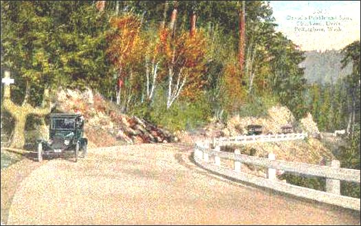
Center: This photo is from Mike Aiken of Acme, a descendant of Birdsey Minkler and the owner of hundreds of vintage postcards. The only notation on the postcard indicates: "No. 3005, David's Pebble and Sling, Chuckanut Drive." We do hope that a reader can tell us where this is and what year Model-T is shown.
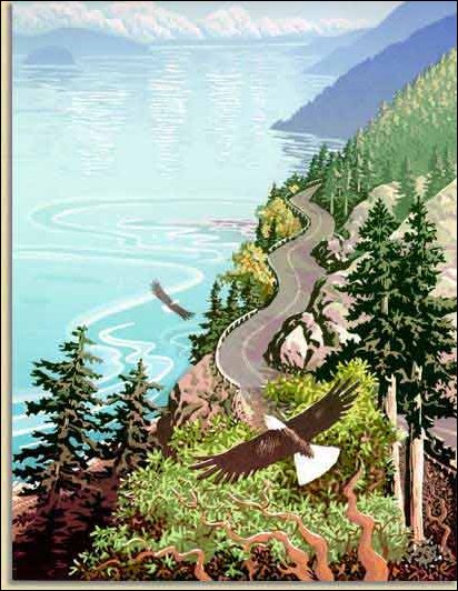
Right: Mystery 2: This drawing of eagles appears to be an illustration for a promotional brochure. Does anyone know exactly what section of Chuckanut drive it portrays and who might have drawn it? Update: an alert reader already responded and noted that this lovely drawing is from this excellent website that gives an overall picture about Chuckanut drive and its history.
|
Chuckanut drive
When I was a child, growing up near Sedro-Woolley, my parents had a ritual for visiting relatives from Missouri. We would take them for a motor trip to Mount Baker and the first leg would be driving up Chuckanut drive. I remember the Chuckanut Manor well and stopping at the Oyster Bar for fresh oysters. A decade later, I used to hang on for dear life behind my late brother on his Vespa scooter as he steered it around all those hairpin curves. Every time I marveled at the panoramic views of the bay during daytime or the hand-hewn rock cliffs that seemed close enough to touch, and at night, I loved the trees whizzing past on each side, the sculpted small boulders that bordered the edge of the highway and the birds flying everywhere.
As a child, I heard many old-timer accounts on those Sunday drives, about how convicts chopped routes through the rock with just pick and sledge-hammers, about the men who fell to their deaths and about the visionaries who chose this most scenic place for a stretch of the original Pacific Highway. And as a freshman college student, I especially remember round-trip train rides with my girlfriend between Western Washington State College and the Great Northern depot near Edmonds on the way to her home in Bothell. That most beautiful of train rides was a perfect opportunity for stolen kisses and sips of champagne. For a few years in 1980s and '90s, that route was closed but Amtrak re-opened it about a decade ago and you can still marvel at the scenery as you whiz by in the Spanish Talgo passenger cars.
We are now researching a story on the history of Chuckanut drive and its construction and we are amazed that are few first-hand accounts have been recorded. We are grateful to Ellen Barton of the Whatcom Council of Governments, who is also trying to piece together the history. She referred us to a marvelous source, a small book on Chuckanut compiled by the late Bob Thomas who and the Chuckanut Community and Firefighters Association, as well as another small book of memories by Francis Judd. We hope that readers will alert us to more such material as well as official and researched histories of the drive.
Briefly, we review the nuts and bolts. The original trail was apparently a military road and the trail may have partially blazed by John Fravel as he strung telegraph wires on the way to Siberia in 1864-65. In 1890, Charles X. Larrabee of F&S fame, along with Cyrus Gates, organized teams to start clearing a roadway. Around the turn of the century, a man from Whatcom named Diedrick Burfiend petitioned to extend a road along the route of the "old Blanchard road." In 1905, blasting and brush clearing began and a couple years later, road clearing was continued with the help of convict labor from the Oyster Creek convict camp. Conflicting dates place the "opening" of the unpaved Chuckanut drive in either 1914 or 1915. We hope that a reader can nail this down for us. By 1920, the road was paved with Macadam except for one mile of hard-rock surface. The wooden bridge at Oyster Creek was replaced with a concrete version in 1925 and the wooden bridge over the gully at Blanchard was replaced with a concrete version in 1930. The entire drive was blacktopped in 1958. Apparently the first auto travel was begun with three very primitive cars in 1903, with counts rising to 7,298 cars in 1921, and 13,037 cars in 1935. If readers have more details, we hope they will send the information by either email or Xeroxed copies to our mailing address, so that we can provide a thorough story on the construction of this beautiful highway.
|
Click on these thumbnail photos to see the full-sized photos
|
|
|
|
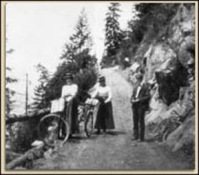
Far left. Mystery 3: Bike riders on Chuckanut. That is all we know. Do you know anything about the photo and location?
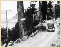
Center: Mystery 4: A Model-T on Chuckanut drive. Do you know anything about the photo and location?
|
|
Further reading and links to all stories
If you are a subscriber, you will find links below to all six exclusive Journal stories about the Interurban, original features, transcripts and compilations that you will find nowhere else. We have included links to two of the stories as samples. If you have not yet subscribed, please join our growing list of subscribers who pay the freight for our extensive, in-depth research. Subscribers: for links to the stories listed below, please return to the Table of Contents for Issue 28. Thank you for your support.
- List of all stories in this issue about the Stone & Webster Interurban, with links and suggestions for further reading.
- We transcribe an article from a 1913 issue of the Mount Vernon Argus that detailed the route of the Interurban. And more Journal research about the birth and demise of the line.
- Help us identify mystery photos and caption them, and submit scans of your own photos for Paul Dorpat's new Washington book and our updated Mystery Photos section. Chapter One features Chuckanut drive, the Interurban and Great Northern.
- A 1982 article about Andy Loft, "Mr. Interurban," who worked for the company for four decades and spent his retirement decades teaching groups, schools and businesses about the importance of the line.
- A schedule for interurban depots and stops and the mileage in between them. Story of the first day of operation in 1912, schedules for the trains and locations of the depots.
- Transcripts of newspaper stories from 1906-11 about the planning and construction of the Interurban.
- Dollar Way in Sedro-Woolley, the first paved highway in the county, which Stone & Webster built as a demonstration project to earn the right of way for the Interurban.
Further reading
- Warren Wing. To Seattle by Trolley. Edmonds, Washington: Pacific Fast Mail, 1988. Wing is one of our favorite authors. His research and citation is impeccable, his selection of photos and presentation of them enhance the text and he has both a sense of place and time. His research and reference to little known people who made their mark is illustrated in this example: "We are all familiar with the inventions of Thomas Edison and Alexander Graham Bell. Yet Frank Sprague, who was their equal, is virtually unknown. Sprague was both an engaging person and an authentic genius. Besides perfecting the electric streetcar his other inventions included the system of multiple unit control that allowed elevated and subway trains to be controlled from a single cab, and the high speed elevator. The reason his name is not as well known today is that the sold his patents to Westinghouse, Otis Elevator and others, he did not insist that his name be associated with the final product. The building of modern skyscrapers, subways and light rail systems would have been impossible without his inventions."
- Daniel E. Turbeville III. The Electric Railway Era in Northwest Washington, 1890-1930. Bellingham: Center for Pacific Northwest Studies (WWU) Occasional Paper No. 12, 1979. Turbeville is an Oregon native who received an M.A. in geography from Western Washington University in 1976. He served as map curator at Western and worked with James Scott of the CPNW to produce the Illustrated Inventory of Historic Bellingham Buildings, 1852-1915. His book on the Interurban is a very important resource that we consult several times a month.
- William D. Middleton. The Interurban Era. Born in Davenport Iowa, the grandson of the first chief surgeon of the Rock Island Lines, Mr. Middleton is a 1950 engineering graduate of Rensselaer Polytechnic Institute and did graduate work in engineering and journalism at the University of Wisconsin and then was an engineering officer in the U.S. Navy. He retired in 1993 and lives in Charlottesville Virginia. He has written several books on this topic: The Time of the Trolley (1967), When the Steam Railroads Electrified (1974), From Bullets to BART and The Last Interurbans.
Story posted on March 27, 2005, and last updated on Sept. 1, 2005
Did you enjoy this story? Please consider subscribing to the optional Subscribers Edition. That is how we fund this grand project.
Please report any broken links or files that do not open and we will send you the correct link. Thank you.
|
You can read about our prime sponsors:
Allelujah Business Systems/Copies/Mailbox, 133-B State St., Sedro-Woolley, 360 855-1157
Preserve your family keepsakes . . . allcopiersystems web page
Schooner Tavern/Cocktails at 621 Metcalf street in downtown Sedro-Woolley, across from Hammer Square: www.schoonerwoolley.com web page . . . History of bar and building
Oliver Hammer Clothes Shop at 817 Metcalf street in downtown Sedro-Woolley, 82 years.
Joy's Sedro-Woolley Bakery-Cafe at 823 Metcalf street in downtown Sedro-Woolley, 82 years.
Heirloom Gardens Natural Foods at 805B Metcalf street, the original home of Oliver Hammer.
Bus Jungquist Furniture at 829 Metcalf street in downtown Sedro-Woolley, 36 years.
Check out Sedro-Woolley First for links to all stories and reasons to shop here first
or make this your destination on your visit or vacation.
Peace and quiet at the Alpine RV Park, just north of Marblemount on Hwy 20
Park your RV or pitch a tent by the Skagit river, just a short driver from Winthrop or Sedro-Woolley.
Would you like to buy a country church, pews, belfry, bell, pastor's quarters and all? Email us for details.
|
|
|
Did you find what you were looking for? If not, please email us and tell us what you seek and we will put it on our list to research. The more details, the better.
|
Please sign our guestbook so our readers will know where you found out about us, or share something you know about the Skagit River or your memories or those of your family. Share your reactions or suggestions or comment on our Journal. Thank you for taking time out of your busy day to visit our site.
|
Sign Our Guestbook

View Our Guestbook
|
Remember, we welcome correction and criticism. Please click on the email slot at the right to report any problems with these pages or to suggest ideas for future stories. This is a completely free site. We fund it by providing an online magazine for paid subscribers. If you are not already a subscriber and you would like to help support our considerable research costs, you can subscribe for just $20.00 per year. As a paid subscriber, you will receive eight yearly issues plus many rare treats between times, including scans of photos and documents that illustrate local history, before they are shared with anyone else. You can go here for Subscription details and you can read the preview edition to see examples of our in-depth research. You may also order gift subscriptions for friends, family or clients who are interested in local history or students or military people who are away from home. Or you can email us for more details. Do you have scanned photos to share? Or you can mail us copies. See addresses to right.
|
Email us at: journal@stumpranchonline.com

Mail copies/documents to street address: Skagit River Journal, 810 Central Ave., Sedro-Woolley, WA, 98284.
|