Site founded Sept. 1, 2000. We passed one million page views on Memorial Day, May 2006
These home pages remain free of any charge. We need donations or subscriptions/gifts.
Please pass on this website link to your family, relatives, friends and clients.

(Seattle & Northern 1890)

Skagit River Journal

of History & Folklore
Subscribers Edition Stories & Photos
The most in-depth, comprehensive site about the Skagit

Covers from British Columbia to Puget Sound. Counties covered: Skagit, Whatcom, Island, San Juan, Snohomish & BC. An evolving history dedicated to committing random acts of historical kindness
Noel V. Bourasaw, editor (bullet) 810 Central Ave., Sedro-Woolley, Washington, 98284
Home of the Tarheel Stomp (bullet) Mortimer Cook slept here & named the town Bug

(Click to send email)

Observing, clearing and opening the Logs
Jams near Mount Vernon, 1870s


(Log Jam)
      This photo shows logs jamming against the Mount Vernon Westside Bridge during high water in 1935. Imagine ten or twenty times that many logs in dozens of floods over two centuries and you can see why a log jam was formed. This view is east with the Condensery Building in the background. Photo from the collection of the late master, Roger Fox, and scanned by Larry Kunzler's www.skagitriverhistory.com website, which has many photos of the river. The jams had trees growing from them as high as 100 feet. Read the theory, as postulated by the Journal editor, that those trees pointed to the 1792 eruption of Mount Baker, as witnessed by both British and Spanish explorers — a theory that has been proven likely to be correct.

      One of our highest goals when we launched the Skagit River Journal website in 2000 was to unearth documentary evidence to back up, supplement or even possibly correct the historical record, as we have it. In line with that, we have been researching rare old newspapers for years. We were fortunate enough to find — with the aid of Donna Sand from Bellingham, notations for articles about the Skagit River Log Jams, which were the biggest challenges to early pioneers and actually discouraged settlement for the first 25 years of Washington Territory. We were then able to find the noted articles with the help of librarians at the Washington State Library. In some cases, these stories update the information available in the 1906 book, Illustrated History of Skagit and Snohomish Counties — the basic history of the area; and in the books of the Skagit County Historical Society series.
      Below you will see a collection of such articles from Eldridge Morse's Northern Star newspaper in Snohomish City and the Washington Standard, one of the feisty early newspapers in Olympia. The Standard was published and edited by John Miller Murphy and partially bankrolled by his brother-in-law, George A. Barnes. The Standard was launched on Nov. 17, 1860, in direct competition with several other fledgling Olympia newspapers. The first newspaper in the Territory was the Columbian, which began on September 11, 1852, led by Thornton F. McElroy and James W. Wiley, who formerly worked for the Portland Oregonian.
      McElroy came west from Illinois in the spring of 1849 in a wagon train, headed towards the California gold fields. When the train party reached Wyoming, they received word that people in the gold fields were "sickly," so he headed instead towards Oregon City, south of Portland. Portland was still a dream but Oregon City was the capital of Oregon Territory. He eventually headed south to the gold rush, but fell ill and returned to Oregon, where he worked for various early newspapers in Oregon City and the new town of Portland. Thomas J. Dryer, editor of the Oregonian, sent the two partners north to Olympia.
      The Columbian began with a literal cannon blast but it barely broke even. Dryer soon fired Wiley, but in 1853, Wiley and a partner with Democrat political leanings showed up with cash, so Dryer sold the paper and it became the Pioneer & Democrat. McElroy continued with the paper until 1860, when he left the operation after learning the hard lesson that a Territorial newspaper without political patronage was a hard sled. The Territorial Legislature eventually appointed him as public printer, a position former held by his former partner Wiley. The Pioneer & Democrat folded in 18973.
      The Standard, meanwhile, launched in 1860 with a front-page story about the election of President Abraham Lincoln. Democrat in political leaning, the Standard supported the Union in the Civil War and championed women's suffrage from its inception. The owner was John Miller Murphy, who would become an Olympia legend. Altogether in the second half of the 19th century, 68 different newspapers came and went in Olympia, half of those publishing for less than two years. At one time six different newspapers competed in the Territorial and State capital, almost all of them aligned with a specific political party. The Standard lasted the longest of all the early Olympia papers, until 1927.
      Starting in 1871, Murphy took on as a partner, Clarence Bagley, who moved his Puget Sound Courier over from Port Townsend and the two launched the Daily Olympian, in conjunction with the Standard. Clarence and his father, the Rev. Daniel Bagley — one of the early Seattle pioneers, were staunch Republicans and they ran Republican dogma in the paper while Murphy was out of town. That started an on-and-off battle for the next few years until Murphy and Bagley parted ways in 1874, and the Olympian went out of business and Bagley became the Public or Territorial Printer. When the stories below were printed, Murphy was at the helm of the Standard alone. He briefly launched the Evening Olympian in February 1889 but soon after the Territory became a State on Nov. 11, 1889, that paper folded, too. The current Olympian newspaper traces its roots to the founding of The Morning Olympian on March 15, 1891, by a group of printers. Murphy sold his interests in the early 1900s to Sam Perkins, who ran various newspapers and finally folded The Olympia Recorder — the successor to the Standard, in 1927. By that time, Perkins owned the predecessor to today's Olympian.
      We will add more stories about the famous Log Jams as we find them. Meanwhile, we hope that readers will send us copies of these old newspapers, especially on this subject, or any of the old newspapers from all over Puget Sound. Below you will find articles from:


The Skagit Jam opened at last
after over two years labor

By Eldridge Morse, The Northern Star, June 12, 1878
      In the fall of 1874, Gen. Michler (or Miehler), of the Engineer Corps, U.S. Army, officially examined and reported the [path?] of a channel through the Skagit Jam. He reported that it would take $15,000 to make a navigable channel through it. It seemed impossible to ever get Congress to appropriate that amount as long as the [unreadable] the Skagit being settled, well after the Territory became a state, even if the jam should be then removed.
      In February 1876, five men, without means, except experience in water logging and nerve and muscle, began the work. They kept up the work ever since, and on Thursday, the 23d of May [1878], the [Wenat?], Capt. Bailey, passed through the Jam and up the river about 14 miles above it, and would have gone further had any preparation been made for her going up the river. This is the first time a steamer ever passed up that river above the jam. The names of the original five who began this work were Marvin Minnick, Daniel Hines, Donald McDonald, John D. Quick and Joseph Wilson. Wilson was succeeded by Dennis Storrs in October (1876?) and Quirk by Fritz Dibbern in December 1876.
      The names of the five who witnessed the opening of the river are Marvin Minnick, Daniel Hines, Donald McDonald, Dennis Storrs and Fritz Dibbern. Mrs. Storrs has done the cooking and house work for the whole crew ever since her husband began work with them in October 1876, besides taken care of four small children. She certainly is entitled to an equal share of credit with the rest of the jam loggers in removing the jam, as she has done an equal share of the work.
      When they began work in February 1876, the jam, or jams, for there were two of them, about three quarters of a mile in length, blocked up the river bank to bank for nearly two miles. The river was almost 1000 feet wide at the upper jam and narrowed down to about 500 feet at the head of the lower jam, and again expanded to 600 to 800 feet. In the lower jam the river averaged about 80 feet deep, places where no sounding could be made in the swift water at the narrowest part. In the upper jam the water averaged in depth about 20 feet, from bank to bank.
      [Unreadable] the lower jam, a channel had to be cut one-fourth of a mile long, through logs wedged in as tightly as possibly for water to wedge them, from the bottom of the river to the surface, and many 20 feet above the surface, and from bank to bank; with mud and sand in many places on the surface of the jam ten feet deep, and trees growing on it ten inches in diameter. They had to slash and [unreadable] the forest of young trees on the jam, before they could commence sawing and getting out he logs and rubbish of the jam proper.
      Then when all the logs on the surface were sawed off and rolled into the water some six successive layers would rise to the surface that had to be treated in a similar manner. In this way a channel one hundred and fifty to two hundred feet wide was cut through solid mass of logs averaging from 30 to 40 feet high for one-fourth of a mile long. This part of the work, the removal of the lower jam, was finished in September 1876, since which time the town of Mt. Vernon and several logging camps have sprung into existence above it.
      Between the main jams were sufficient obstacles to require nearly one quarter of a mile of cutting before the upper jam was really reached; this took until March 1877. This part left in a body, blocking up the courses of the river, so that steamers could not enter until it was removed, which took about two months of their time.
      Work on the upper jam was commenced in May 1877. In clearing the lower river, five or six men had been employed for a short time so as to interfere as little as possible with its navigation. That is nearly all the extra help ever employed.
      Work has been kept up on the upper jam since May 1877 to date. There is now a channel about 100 feet wide, and three quarters of a mile long through the upper jam. These loggers will probably work another year in widening this channel, and in clearing drift and logs from the river. When completed, the channel will in no place be less than 200 feet wide, most of the way 500 feet, and in some places it will be cleared from bank to bank 1,000 feet wide.
      These men have given nearly two and a half years time and labor and propose to give another year's labor to complete their work. Their labor has been of the hardest and most dangerous character. This work has opened up to settlement a valley as fertile and nearly as large as the famous Connecticut River valley in New England, one that when developed may contain over 100,000 in habitants. They have received no Government aid whatever. Individuals have contributed about $450.00 in cash and merchandise; some $800.00 more is promised them but not paid.
      In a single week, by the breaking up of parts of the jam, they have lost as much as $150 worth of tools. A large part of the implements used they manufactured themselves; and they have lost and used up of tools purchased over $60 worth besides [unreadable] and rafts destroyed. They have received no other assistance except what logs they have out of the jams. Those have been little more than sufficient to furnish them with tools and necessary provisions.
      The ancients considered it as among the claims for deification, proper to be allowed that Hercules cleared the Augcan [Aegean?] Stables; great as that feat of physical labor was, it bears no comparison whatever to the work required to be done in removing the Skagit jams, of the nerve and endurance exerted by these hardy loggers. Surely they deserve from the government, as from the citizens of the [unreadable] . . . [clipping ends there]


The Skagit River Country
Washington Standard, Saturday, Aug. 2, 1873
(Finney Creek)
This is another photo from a fine website by Skagit Fisheries Enhancement Group, a newsletter called The Redd, edited by Alison Studley, with assistance from the US Forest Service. Caption: "Roger Nichols of the US Forest Service inspects one of the logjams after the October 2003 floods."

      Many of our oldest residents will be surprised at the information that we have a river in the Territory quite as large as the Willamette of Oregon, and which runs through a fertile valley from five to six miles wide and upwards of eighty miles in length. But such is the Skagit River and valley, as we learn from a letter written by Rev. J.F. DeVare [maybe J.Y. Deere?], who has been on a visit to that part of the Territory. He says that the valley is covered mostly with balm [?] and blackadder [black alder?], both of which are easily removed.
      The products are wheat, 40 bushels per acre; oats, 75 to 100 bushels per acre, potatoes, 300 per acre; hay, two tons per acre; also cattle and hogs are abundant. There are also wild game such as elk, deer, bear, cougars, wild cat, grouse, and the rive abounds with a splendid article of salmon, which will justify, as I think, the establishing of fisheries, as on the Columbia river.
      The settlers are as yet mostly below the jam on the north and south channel [forks] and number about seventy-five farms already opened. Indications are that in a very few years, with the jam removed, there must be a very large business carried on in this part of our country. There is certainly room for at least twenty-five thousand people on this river; then, with this region settled and steamers plying up and down, it will become one of the very desirable portions of the great Northwest." He represents the location as beautiful, the soil as fertile and the settlers hospitable and willing to impart all information to those seeking homes with them.


Introducing the Skagit River
Washington Standard, April 29, 1876
      Very few of our readers are aware of the size and length of some of the rivers flowing into the Sound or of the large tracts of fertile land, which lie on their borders, available for settlement, soon as natural obstructions are removed. The Skagit river, according to the report of the editor of the Northern Star, who has recently visited that district, and consequently formed his [informed?] personal observation, can be made navigable for light-draught steamers, a distance of seventy-five miles.
      It rises east of the Cascade Mountains [actually in the lower British Columbia mainland] and receives much of its water from streams draining Mount Baker [such as the Baker River] and other high peaks. Its waters are consequently higher in Summer than in Winter, rise slower and do not ordinarily overflow the banks, as in rivers subjects to freshets whenever a prolonged season of rainy weather, extending over a wide extent of country, saturates the earth and taxes to the utmost these natural drains. [Journal Ed. note: that attitude largely prevailed until the triplet floods of 1894, 1896 and 1897 blew that theory to smithereens. You can read more in our flood section, where you will also find links for Larry Kunzler's extensive website about Skagit floods.]
      The Skagit flows into the Sound by two mouths, called the North and South forks, forming a delta, on which the new townsite of Skagit City has been laid out. It is located upon bottom land, above the reach of high water. [For more information about Skagit City, see the announcement in this 1884 newspaper and follow the link from there. The North Fork is about five miles long and enters the Sound about five miles [south] from LaConner, and the Swinomish flats are considered part of the river valley. The South Fork is the main channel, about eight miles long, and can be easily ascended by light-draught steamers at any season of the year.
      The peculiar nature of the river is the Jam, about two miles above Skagit City. The lower portion of this obstruction is about a quarter of a mile in length, and the river is clear for three-fourths of a mile to the upper jam, which is half a mile long. It is composed of driftwood, the accumulation of many years, which has become so firmly interwoven that its removal is an engineering problem of no small magnitude. The jam is the great bar to an extension of settlement and the progress of civilization to the head of the river. Only two families have settled above the jam. [Journal Ed. note: at this point, we know of only one such family that was "above" or north of the jam, that being Jasper Gates, who claimed the land that included most of downtown and northern Mount Vernon. His fellow settler, David E. Kimble was located near what is now called Britt's Slough — on the point beside the lower jam. The writer may have meant Joseph F. Dwelley, who pre-empted a claim beside Gates, but by the time this article was written, Dwelley had already removed his family to LaConner. We are still trying to determine where Dwelley's original claim was located and we hope that a reader can eventually help us.]
      All of the settlements are crowded within the delta or along the forks of the river [Mann's Landing/Fir and Skagit City, while a magnificent country along a fine navigable steam for over sixty miles above the jam is by this means [the jams] prevented from being opened to settlement and cultivation, to say nothing if the numberless mines of the best coal found on the Sound], or the great amount of the [great?] timber that this obstacle prevents coming into market. Logging can be carried on only to a limited extent until after their removal, as the high land is too far back from the river to haul lumber from. Even the most favorable townsite, Skagit City, was located on the bottomland, near the forks, for the reason of there being no high land on the river below the jam.
      Perhaps no river in this Territory offers greater inducements than this for settlement, provided this jam was removed. The bottomland, timbered mainly with alder, vine maple, etc., is more easily cleared than the Stillaguamish, Snohomish, or most other river bottomlands in the Territory. The timber on the high land is of excellent quality, as well as easy to get out and float down, there being few obstacles in running logs, after the removal of the jams, to what are found on other rivers, the current of the Skagit being steadier and slower than the Snohomish [River to the south].
      Several coal mines are being prospected, and some work done toward opening them; two of the mines are situated below the jam [we know nothing of such a claim], and between the South Fork of the river and the Stillaguamish. The rest are above; the removal of the jam is necessary to secure their early development. Can we wonder then that the whole energies of the people are directed towards obtaining Government aid for the removal of this obstruction or is there an object on which the people of the Territory more properly unite?


Skagit Log Jam Dislodging
Washington Standard, April 21, 1877
      High water has carried out more of the jam on the Skagit river, a stream entering the Sound north of Seattle. This will give an impetus to the settlement of that great valley.

Removal of (Skagit) Jams
Washington Standard, Dec. 1, 1877
      Capt. J. S. Hill, of the steamer Fanny Lake, informs the [Seattle] Intelligencer that the jam of logs in the Stillaguamish river was entirely swept out by the late freshet [flood] leaving that river navigable for steamers at eighteen miles above the present head of navigation. On Tuesday morning, Capt. hill was ascending the Skagit river and had nearly reached Gage's store [at Skagit City and the fork of the river] when he descried a vast raft of timber coming down the stream, and knowing there was but little chance to dodge it, he promptly stopped and backed around, after which he made the best of his way out of the river.
      He has no means of definite information, but believes that a large portion of the great jam has disappeared. Should this be the fact on the Skagit, as well as on the Stillaguamish, it opens up for settlement lands enough to support several thousand families, accessible by a few hours' steaming, to the second largest city on the northern coast. Even if the Stillaguamish alone is opened, five hundred families can find good homes and abundant employment there.
      Several Scandinavian families have moved in here during the past month and they are a very desirable element of population, being generally thrifty, industrious and peaceable. The banks of these rivers abound in the most remarketable [remarkable?] timber to be found anywhere about the Sound, and after the trees are cut away, these abandoned logging camps will become excellent dairy farms. Should the next two years show a similar increase of population, Snohomish [clipping ends there] . . .


Jams now completely open to steamers
Washington Standard, Sept. 26, 1879
      The jam that has so long impeded navigation on the Skagit river is, at last, open to steamers, resulting in lessening the time between Seattle and LaConner [spelled La Conner in this article] about two hours.
      [Journal Ed. note: this is a strange statement because the jams were not located between LaConner and Seattle, but instead almost due east of LaConner. But regardless, this date is important.]


Links, background reading and sources


      See this Journal website for a timeline of local, state, national and international events for years of the pioneer period.
      Search the entire Journal site.

You can click the donation button to contribute to the upkeep of this site at a time when we may be forced to cut it back for lack of funds. You can also subscribe to our optional Subscribers-Paid Journal magazine online, which is about to enter its sixth year with exclusive stories, in-depth research and photos that are shared with our subscribers first. If you like what you read, thank you in advance for whatever support you can provide. You can go here to read the preview edition to see examples of our in-depth research.
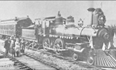
(bullet) Story posted on March 25, 2006
(bullet) Did you enjoy this story? Remember, as with all our features, this story is a draft and will evolve as we discover more information and photos. This process continues until we eventually compile a book about Northwest history.
(bullet) Can you help? We welcome correction and criticism.
(bullet) Please report any broken links or files that do not open and we will send you the correct link. With more than 500 features, we depend on your report. Thank you.


Return to our home page anytime

You can read the history websites about our prime sponsors:
(bullet) Jones and Solveig Atterberry, NorthWest Properties Aiken & Associates: . . . See our website
Please let us show you residential and commercial property in Sedro-Woolley and Skagit County 2204 Riverside Drive, Mount Vernon, Washington . . . 360 708-8935 . . . 360 708-1729
(bullet) Schooner Tavern/Cocktails at 621 Metcalf Street in downtown Sedro-Woolley, across from Hammer Square: www.schoonerwoolley.com web page . . . History of bar and building
(bullet) Oliver Hammer Clothes Shop at 817 Metcalf Street in downtown Sedro-Woolley, 82 years.
(bullet) Joy's Sedro-Woolley Bakery-Cafe at 823 Metcalf Street in downtown Sedro-Woolley, 82 years.
(bullet) Check out Sedro-Woolley First section for links to all stories and reasons to shop here first
or make this your destination on your visit or vacation.
(bullet) DelNagro Masonry Brick, block, stone — See our work at the new Hammer Heritage Square
See our website www.4bricklayers.com
(bullet) Are you looking to buy or sell a historic property, business or residence? We may be able to assist. Email us for details.
(bullet) Peace and quiet at the Alpine RV Park, just north of Marblemount on Hwy 20
Park your RV or pitch a tent by the Skagit river, just a short drive from Winthrop or Sedro-Woolley

Looking for something special on our site? Enter name, town or subject, then press "Find" Search this site powered by FreeFind
    Did you find what you were seeking? We have helped many people find individual names or places, so email if you have any difficulty.
    Tip: Put quotation marks around a specific name or item of two words or more, and then experiment with different combinations of the words without quote marks. We are currently researching some of the names most recently searched for — check the list here. Maybe you have searched for one of them?
Please sign our guestbook so our readers will know where you found out about us, or share something you know about the Skagit River or your memories or those of your family. Share your reactions or suggestions or comment on our Journal. Thank you for taking time out of your busy day to visit our site.

View My Guestbook
Sign My Guestbook
Email us at: journal@stumpranchonline.com
(Click to send email)
Mail copies/documents to Street address: Skagit River Journal, 810 Central Ave., Sedro-Woolley, WA, 98284.